
The digital information age that we live in allows us to see and discuss various attributes of Bighorn Sheep habitat that was once largely hidden. Prior to this information age this type of knowledge was solely the domain of those that could track and read sign and spent a lot of time in a particular mountain range or region. While the ancient art of tracking and reading sign is information rich it often leaves the transmission of this information in the realm of opinions and hearsay due to the fact there is no transmittable graphic record. To use this traditional information for any kind of management or environmental decision it will always be necessary to assess the personality and skills of the person or persons giving the opinion. Then invariably after making a decision the decision-makers will have to rely on the same type of skills and opinion to assess the outcome with little or no graphic representation.
One of the most common and powerful tools of this new information age is the trail camera. The modern trail camera is an amazing piece of equipment. It is highly programmable can take still pictures night and day as well as video and hold a tremendous amount of data. They can hold tens of thousands of still pictures with the resolution currently at about 20 megapixels. Indeed anybody that has used these cameras can tell you that you can quickly go into data overload. Putting up one of these cameras at a spring or water source is as if a person sat by that water source and watched it 24/7 for weeks and even months at a time and photographed what happened. Spending the time to go through and interpret this data often requires a considerable amount of time and effort.
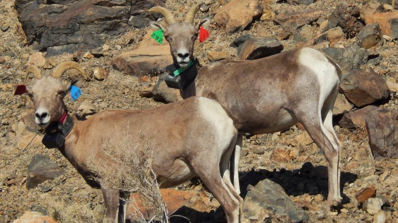
Another very useful technology in this information age is the radio or satellite collar. Nowadays these devices transmit the whereabouts of a particular Desert Bighorn Sheep to the Internet via satellite. Due to the cost and the fact you have to first capture these animals to put the collar on, means that there’s not as much of this type of data available. However this data is usually worth the effort it takes to get. There are a lot of things that this type of information can show that is difficult to get otherwise, such as the sheep’s placement due to weather, vegetation, and time of the year, as well as many other factors.
Now let’s talk about a very inexpensive and easy to use yet powerful tool we have in this information age. That is satellite imagery, most notably Google Earth. The resolution of these images is incredible and while I have never found a discernible image of a bighorn sheep it is possible to make out people on certain hiking trails in the Grand Canyon. One of the key abilities of these images is their detailed rendering of vegetation. Often times vegetation patterns are key to finding water that is not otherwise known about, such as springs that are not on topographical maps or do not have a name, or a road leading up to them. Another attribute that these images have is the ability and resolution to reveal game trails. While game trails don’t always lead to water, many do. Often times game trails that are in the proximity of water are the only clue you have of that water’s existence, due to the fact it’s either too small, or they do not have any other tell-tale sign such as vegetation to indicate its location.
Now I’d like to speculate on a technology I know exists but to my knowledge has never been applied in an attempt to have deeper knowledge of wild sheep. This is a form of satellite image technology that covers various spectrums of light in an effort to ascertain the health of various crops. This type of imagery could reveal an in-depth understanding on rain events. Rain events are complex events. To understand them one must to take into consideration the time of year, the type of rain, such as a summer thunderstorm or a wide-ranging winter rain. Then take into account such things as the wind, the ground temperature and the radiant energy from the sun before and after the event and many other important factors. This can be difficult to sum up especially without spending weeks if not months in that particular location. All the while this is summed up in the biomechanical process of the plant, which to a large extent can be revealed in a graphic satellite image that is taken in various wavelengths of light. This will give the viewer a detailed understanding of the plant side of the plant-sheep interface. This can literally shed new light on the population dynamics of Desert Bighorn Sheep.
Like so many things, when you bring together these technologies they are much more than the sum of their parts. For instance, a trail camera can tell you many things yet it cannot tell you where the sheep came from or where they went to. Likewise the satellite collar can tell you everywhere one particular sheep has gone, though not what other sheep were with it. Then when you put together these two information sources in conjunction with satellite imagery you can achieve a level of understanding and the ability to discuss these things that is only possible in this high-tech information age.
Now I would like to enter into a discussion that will showcase what these individual information technologies can do, as well as what the convergence of these technologies can accomplish. To do this we will talk about some water sources in the North Bristol Mountains of California.
We will start with a tale of two springs. One is known as Hyton Tank and the other as Hyton Springs. Hyton Tank is a spring that has been augmented with a tank and is taken care of by the Society for Conservation of Bighorn Sheep. There have been cameras on both of these on and off for a number of years. We also have a fair amount of satellite collared sheep in the North Bristol mountains. This data shows that the sheep overwhelmingly prefer to use Hyton Tank as opposed to Hyton Springs. The most likely reason for this is the close proximity of mineral sources at Hyton Tank. Over the course of the years at Hyton Tank there has been tens of thousands of pictures taken of the Desert Bighorn Sheep and very few photos that show predators. Hyton Springs seems to be the opposite, there are a lot of predators and very little use by the Desert Bighorn Sheep.
These two water sources are approximately a mile and a half away from each other and are both in reasonable escape terrain. So the desert bighorn sheep could use either one for water if that’s all they wanted. I first noticed the sheep using the area around Hyton Tank for minerals using the old methods of tracking and reading sign. Then it was verified by me and other people using trail cameras placed directly on the mineral sources. The idea that I want to put out here is just because we have a focus point water source in the desert being used by the Desert Bighorn Sheep, it may still be advantageous to put another one in close proximity, especially if we consider the effect of mineral sources. While putting a water source close to another may seem counterintuitive, when you see the data on these two water sources it tells an interesting story. There are number of localized mineral sources in this area. Delving into the satellite coller data may indicate which mineral sources they prefer. Then this would allow us to sample these minerals and find out what makes them valuable to the bighorn sheep and explore any possibility there might be a detrimental mineral element in them.
Now let’s talk about some observations and ideas about what might be going on in the North end of the North Bristol Mountains. Some time ago I was shown some satellite tracking data of two ewes starting from two different places and ending up together in the North end of the North Bristol Mountains. After seeing this I looked up the area on Google Earth. There were no obvious water sources, though I could see that where these two sheep met there were some well-defined game trails. I still thought there might be a liquid water source there in the form of a tinaja or small spring. So I went there to investigate and found no sign of liquid water of any kind. This area was comprised of excellent escape terrain with a fair amount of places that had deep and permanent shade. For Desert Bighorn Sheep, good deep shade can be considered a form of water as it is utilized in such a way as to prevent these animals from drying out. Furthermore there was an abundance of barrel cactus which is also a source of moisture/water for these animals. There were also some sand dunes, many of which had a North Slope exposure, this allowed moist leafy annual plants to grow where otherwise they would not. These three attributes combined make for a usable amount of water as far as Desert Bighorn Sheep are concerned. It’s also interesting to note that in this area there are mineral sources that look very similar to the ones that are at Hyton Tank.
The fact that there is no focus point liquid water source in the North end of the North Bristol’s, reduces the effectiveness of trail cameras. However these trail cameras can be put on game trails as the name implies and deliver usable numbers of pictures/data in a situation like this. Hopefully someday we will have this type of data from this place. When these pictures are compounded by satellite data you’ll get a very clear and accurate picture of what is going on there. Also you can put cameras at Hyton Tank and when these collered animals show up there you will be able to see what other animals are with them, most importantly lambs. This would let us know if the North end of the North Bristol’s is a lambing ground or not. I suspect this is a lambing ground and that examining the satellite collar data that we already have will reveal this.
One of things to consider about this situation is the lack of liquid water and the significance it may play in this portion of their habitat. If in fact there is no liquid water anywhere near this place and it is a lambing ground this would have some interesting implications. This lack of liquid water would tend to reduce the activities of predators such as coyotes, bobcats, and mountain lion. While no doubt they can make forays into this area they will not be able to stay long as these animals have a higher need for liquid water. What this also indicates that putting an artificial liquid water source into this part of their habitat may be detrimental to this population of the Desert Bighorn Sheep. Generally adding water is always looked at as a positive for a population of Desert Bighorn Sheep. Here we have a prime example of our ability to view and discuss the attributes of a particular piece of Desert Bighorn Sheep habitat and their behavior that is only possible in this high-tech information age.